|
|
||
|
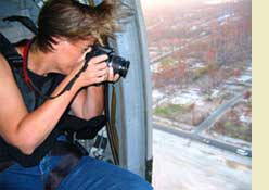
I was also, as it happened, the principal editor for DPZ's [dpz.com link] SmartCode, a unified design and development code for towns and cities, based on smart growth and New Urbanist [cnu.org link] principles. I'd fallen for the SmartCode as soon as I read it in 2004. I could visualize the kinds of places it was meant to protect and create, having spent half a lifetime photographing them. My work on the SmartCode naturally became another way to honor my subject matter. Photography is a big part of the planning and coding process, and the concurrent shift of color photography to digital technologies allowed me to shoot even more places, distribute images quickly to other planners, and analyze buildings, neighborhoods and regions based on them. Because of my work on the SmartCode with Andres Duany and DPZ, I was invited to head the Codes Team at the Mississippi Renewal Forum, [mississippirenewal.com link] a week-long planning charrette organized with efficient urgency six weeks after Katrina. Many smaller charrettes and consultations followed. Photo: October 11, 2005. Shooting the Mississippi Coast the night before the Renewal Forum charrette. Credit: Leah Stroble. |
||
 Biography